By Eric Sack, FLO Analytics
FLO Analytics is the GIS services provider for the AWC GIS Consortium. Learn more about the Consortium here.
For the City of Sammamish and the City of Harrington in Washington State, it was the best of times, it was the worst of times—until these cities discovered a GIS Consortium run by Association of Washington Cities. Now it’s just the best of
times! From small rural towns to dense urban areas, the AWC GIS Consortium is helping local governments make the best of all available GIS and data resources, implementing solutions that provide big gains in operational efficiencies for local governments.
This tale of two cities and their GIS projects will show you how.
Let us set the scene…
Cities rely on accurate and current data to keep operations running smoothly, but it can be a big challenge to manage data and keep on top of the latest technology and best practices if it’s not your full-time job. FLO Analytics, the GIS and data services provider for the AWC GIS Consortium, specializes in using Esri tools to implement GIS workflows for small to mid-sized cities. Our experience over the last nine years has enabled
us to assist cities with delivering sound and cost-effective solutions that are well-configured and easy to use, perform time-saving analyses and reporting functions, and allow for a big payoff from the long-term investment in GIS!
FLO has found that cities often fall into two categories when it comes to GIS implementations. We have used two AWC GIS Consortium members, City of Sammamish and City of Harrington, to showcase some of the ways each city is benefiting from an investment
in GIS.
The tale of city one: Sammamish, Tier 4 GIS Consortium member
A GIS program that runs like a well-oiled machine, but with room for impactful enhancements.
The City of Sammamish has a mature and well-designed GIS program with departmental staff supported by a core GIS team responsible for managing an Enterprise GIS system. A CityWorks asset management system is integrated with GIS data, as is a TRAKiT permit
application and management system. The city continually invests in all aspects of their GIS, refining systems, workflows, data acquisition, collection, and cleanup efforts that add value for the community—as well as for city staff and other
local agencies through collaborative data sharing.
Dedicated GIS professionals manage the complex workflows that integrate spatial and nonspatial data into a series of easy-to-use field applications and dashboards. These components allow for permit integration, planning optimization, asset management,
and community access to information. FLO has helped, and continues to assist, with SQL script writing and updates, advanced python scripting to tie all the pieces together without manual interactions, and providing overall direction to technically
implement the GIS system the city envisions by creating and sticking with a detailed needs assessment and implementation plan.
City of Sammamish’s GIS implementation timeline
2013: GIS staff in departments, GIS administrator on board, budget planning, optimized resource allocation, ArcGIS server.
2014–2015: Data assembly, asset management system layer construction/conversion and setup, application hosting in Esri's ArcGIS Online environment.
2016–2018: Asset management system integration, scripting and automation, data cleansing, community engagement, development of a GIS strategic plan, GIS moved inside the IT department, GIS gets general funding.
2019–2021: Permit application upgrade, new integration requirements, Enterprise GIS expansion, ArcGIS Collector field use.
2022: Planned ArcGIS Enterprise expansion with high potential for deployment of ArcGIS solutions.
City of Sammamish GIS has added an open data portal hosted through Esri that allows users to search and download city GIS data.

City of Sammamish’s most popular GIS web application is the "Storm Bandit" shown above. It allows the access to a plethora of storm related GIS layers with intuitive search, ID, and query widgets.
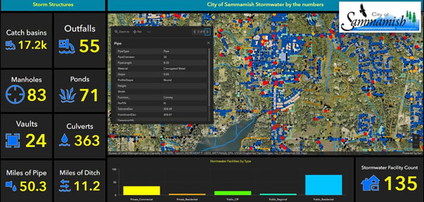
FLO has been tasked to configure intuitive Esri Dashboards that are allowing transparent access to many key performance indicators that are driving action in the city. Managers, data editors, and field technicians are relying on data-driven, real-time
feeds that make these dashboards invaluable.
A tale of city two: City of Harrington, Tier 2 GIS Consortium member
A city with a new GIS with lots of room to grow!
In 2019, on a limited budget, City of Harrington began implementing a GIS system with the aim of capturing institutional knowledge, converting paper maps to digital format, updating and maintaining their utility assets (storm, sewer, and water), and engaging
the community with spatial applications.
City of Harrington’s GIS implementation timeline
2019: Build an ArcGIS Online site; convert data from paper to digital; collect utility asset data using high-accuracy GPS; deploy editable maps, apps, and dashboards to engage the community
2021: Cemetery application, paper map conversion
2022: Drone aerial data collection and digital elevation model generation, refinement of spatial data and creation of details road/sidewalk/street sign inventory, and creation of GIS layers
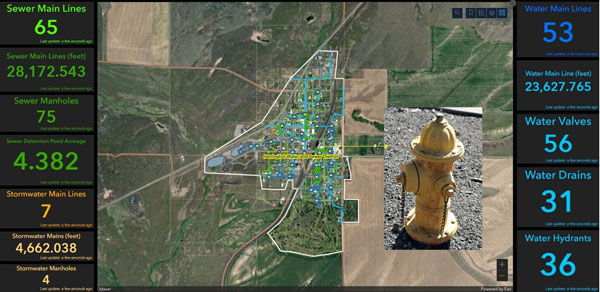
City of Harrington uses FLO Esri dashboard to show total counts of assets, photos of hydrants, and to check attribution for selected features.
What we can learn from this tale of two cities
Sammamish and Harrington have both done a great job prioritizing their GIS investment—resulting in better data, increased efficiencies, field data collection enhancements, and overall community engagement and trust in how the cities are managing
GIS resources. Both Sammamish and Harrington are seeing great returns from their GIS investments in the form of:
- Integrated permit and asset management systems that are driven by sound GIS data, workflows, and automation
- Asset locations that are trusted and represent the needed precision for planning, modeling, and resource allocation
- A clean and planned vision for implementing value-added workflows, datasets, applications, dashboards, and community involvement tools
- Internal GIS applications helping staff answer questions quickly
- Applications and tools that community members can—and do—access and use
Like we said, it’s the best of times!
Thanks to City of Sammamish and City of Harrington for letting us share their GIS success stories! The AWC GIS Consortium is helping cities across Washington State use GIS and data to improve communities. Learn more at here or email gis@awcnet.org.